
PROTECT YOUR DNA WITH QUANTUM TECHNOLOGY
Orgo-Life the new way to the future Advertising by AdpathwayGeneral
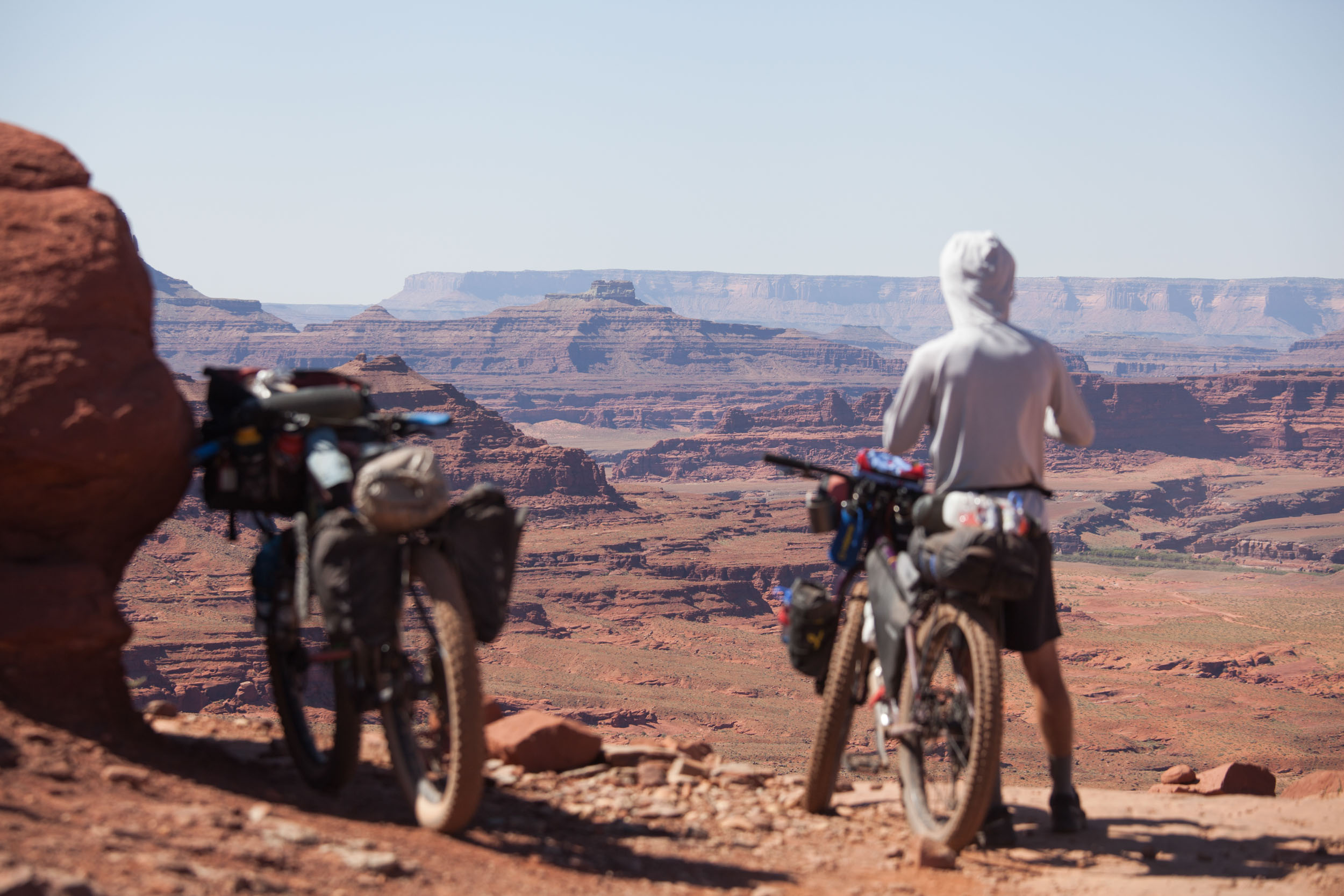
- This is an adventurous route! There will be sections of persistently wet old road, technical singletrack, some slick rocks, steep climbs, and overgrowth. There will be many more sections of smooth gravel road, mellow doubletrack, stone dust rail trail, and even some flowy singletrack. Overall, it is a well-balanced route, but don’t underestimate the terrain. Check out the venerated VTXL if you are looking for a more mellow tour.
- The ideal bike for this route is a hardtail mountain bike with fast-rolling tires and a front fork that can be locked out for extended gravel stretches. Any bike that can run a mid-size mountain bike tire or larger (2.35″) should work, although there are some sections of singletrack that could be challenging without front suspension. Tires should have enough tread to lend grip on variable terrain and periodic damp sections.
- Mid-June to October is the general time window for this route. Typically, the best weather and riding conditions will be found from mid-August through early October. June and July tend to be hotter, wetter, and more humid. Early summer can also bring out many biting insects, particularly in northern areas. NOTE: if riding before June 1st or after November 1st (neither is advised), you must chart a detour around the Green Woodlands Trails (miles 24-36), which are closed to bikes from November through May.
- Ride it counter-clockwise for better overall flow and memorable descents.
- Many of the singletrack trails along this route are located on private land. Permission has been granted from each trail manager for the inclusion of their trails in this route. Please respect all trail system rules and remember to Ride with Gratitude so that all may continue to enjoy these trails for generations to come. If there has been significant rain recently, it is worth checking TrailForks/socials for possible trail closures.
- This route uses several Class 4 roads (Vermont) and Class 6 roads (New Hampshire). These mostly unmaintained town highways follow legal public rights-of-way. A few have gates, others pass very close to barns and residences, and some are lined with No Trespassing signs on either side. It might feel like you are riding into someone’s driveway or entering private property in spots. While this can be a bit intimidating, be assured that you are indeed permitted to pass through these roads. Ride with confidence, be friendly and respectful to abutting landowners, and don’t linger next to homes.
- Don’t forget the Vermont gravel road wave (also useful in New Hampshire).
Logistics
- Long-term parking in downtown Lebanon, NH, is limited. For information on available parking locations, contact the Lebanon Parks and Recreation Department at least a few business days before your arrival (p: (603) 448-5121, e: recreation(at)lebanonnh.gov); City staff will let you know where to park.
- Lebanon is easy to get to by northern New England standards. Dartmouth Coach offers bus service to Lebanon from Boston, NYC, and Manchester, NH airports. It’s also possible to fly into the small Lebanon airport via Cape Air. Amtrak passenger rail will get you to neighboring White River Junction, VT, from NYC, Hartford, CT, or Burlington, VT. Lebanon has two excellent bike shops, multiple supermarkets, and a variety of overnight accommodations.
- Out on the route, resupplying is generally pretty easy throughout thanks to periodic general stores and plentiful surface waters.
- Along the route, there are bike shops in Littleton, NH, Colebrook, NH, and East Burke, VT, for mid-ride needs.
- A one-day membership and waiver form is required to access the Kingdom Trails singletrack network and should be purchased/signed online on the day you are accessing the trails.
Dangers and Annoyances
- This route uses a handful of backroads that could have active logging operations. Logging trucks are huge and may be hauling extremely heavy payloads on narrow, steep roads. You need to yield aggressively to these vehicles. To borrow guidance from the Eastern Divide Trail’s Lupine write-up: Please yield to all logging traffic. Be super predictable by pulling all the way off to the side of the road, giving the trucks plenty of space, and waving a friendly hello as the truck drives past. We’ve never had an issue with truckers, and friendly waves always get returned. The key to getting more lands open to us in the future lies here.
- Northern Vermont and New Hampshire have experienced some severe flood events in recent years. These have tended to occur in early to mid-summer. Research possible road or trail closures before your trip. If a road is posted as closed, that means it is closed to all road users; you must detour. If you come across active road repair work, do not pass through without first communicating with the road crew. This message was specifically communicated to the bikepacking community by road agencies following recent flood events in Vermont.
- There are a few damp sections of backroad and trail with occasional slick rocks and roots, use extra caution here.
- There are a few brief stretches of state highway on the route. None are especially high traffic, but caution should be used. A blinking rear light is useful to have.
- A few of the roads and trails are shared with ATVs (they are usually signed). It’s best practice to yield to ATV traffic. These are not particularly high-use or high-speed trails, and my encounters with ATV riders have always been respectful and friendly. There has been a lot of work done in this region to promote positive coexistence on these trails; a friendly wave while yielding can go a long way.
- Ticks are present along the route. A daily tick check is a good practice.
- Biting insects can be an annoyance, especially earlier in the summer along northern stretches. Loose, long-sleeved clothing is a good first line of defense.
- The entire route is in black bear country.
- Moose can also be found anywhere along this route, most frequently in northern areas. Use extreme caution if encountered.
- Hunting takes place in forests all along the route, so bring some blaze orange if riding during hunting season.
- As noted in the main description, the route passes through many land jurisdictions. There is a lot of private land (some posted), and public lands are managed by a range of federal, state, and local agencies, each with their own regulations. Some of the notable public lands camping options and restrictions are listed below, but this is not an exhaustive list. Be sure to scope out camping options and restrictions in advance.
- There are a number of campgrounds and established camp spots along the route. Many are marked with POIs. HipCamps and Airbnbs are an option in some places, as are many small inns, motels, and bed and breakfasts in and around towns.
- White Mountain National Forest (NH) offers a number of primitive first-come, first-served tent sites (general areas marked with waypoints) and reservable paid sites and permits wild camping in most areas. Consult the WMNF’s Backcountry Camping Rules for details.
- The route connects several Vermont State Park campgrounds. Reservations are required. Online registration will come with a minimum two-night stay. Call the State Parks reservations hotline and tell them you are arriving via bicycle, and they will book you a one-night stay.
- The shelter on top of Wrights Mountain in Vermont is first-come, first-served and is perched on a ledge with a splendid view. Dispersed tent camping is also permitted here. Note that there is no water source on the summit.
- Camping is not permitted in the Silvio O. Conte National Fish and Wildlife Refuge, New Hampshire’s Nash Stream Forest, or the Army Corps’ Union Village Dam Recreation Area.
- Camping is not permitted along the Green Woodlands Trails, which are located on private land (miles 24 to 36). However, there are some excellent lodging options that can be accessed via the trail network (see marked POIs on the map).
- Similarly, camping is not permitted in the Kingdom Trails network, but there are many camping and lodging options nearby.
- There are some longer stretches between established camping areas and public lands. There are plenty of remote forests where wild camping out of sight is possible. However, you should use good judgment and be aware that some residents and land managers can be protective of their property. If wild camping is a must, make an effort to obtain landowner permission. Otherwise, I recommend setting up after dusk, departing before dawn, and leaving no trace. Abide by any No Trespassing signs.
- Waste disposal soapbox: If you are planning to rely on primitive or dispersed camping options, please properly dispose of #2 in a well-dug hole far from any water sources and pack out your toilet paper. Better yet, try to take advantage of in-town accommodations when possible to limit human waste impacts in sensitive ecological areas.
- There are a variety of general stores along or close to the route marked on the map. These stores have their charms and their quirks. Offerings vary. Some stores have made-to-order menus, pre-made sandwiches, fresh baked goods, and/or well-stocked markets; others have typical gas station fare. General stores often close on the early side (double-check hours if anticipating an evening arrival), and some are not open every day.
- There are full-service grocery stores in Littleton, NH, and Lyndon, VT, for general resupply needs. Colebrook, NH, has a smaller grocery store as well.
- In New Hampshire, Littleton and Bethlehem have some quality sit-down and takeout meal options. There are often food trucks at some Kingdom Trails trailheads in East Burke, VT (as well as other tasty offerings at brick and mortar establishments in town). Danville, VT, also has multiple excellent food establishments.
- Water is easily found along the route. General stores will usually have a sink or tap to fill water bottles. There are many natural sources of water along the route as well. All naturally collected water should be treated or filtered. Consider the source and surrounding land uses when deciding whether to filter or treat. Advanced planning is needed for water if camping on the summit of Wrights Mountain, where there is a shelter but no water source.
Full Riding Surface Breakdown
- Gravel roads: 39%
- Paved roads: 20%
- Rougher back roads and doubletrack: 19%
- Stone dust rail trails: 12%
- Singletrack trails: 10%
Detours and Shortcuts
If you’re looking for a shorter tour, you can cut off the loop by following the Eastern Divide Trail route between Bath, NH, and South Ryegate, VT. This would result in a ~270-mile northern loop or a ~150-mile southern loop. There are other spots where bridges over the Connecticut River could be used to support modified loops as well. There are a few options for minor detours to add or remove singletrack:
- Green Woodlands (Dorchester, NH). The route uses about 9 miles of singletrack in this network. There are plenty of opportunities to do additional exploration or connect to multiple lodgings adjacent to these trails. Most of these trails are machine-built and are generally flowy by northern New England standards. The trails intersect with main gravel roads in a few places if you would prefer less singletrack.
- Tunnel Brook Trail (White Mountain National Forest, NH). Tunnel Brook Trail is a true backcountry mountain bike experience, a rarity in northern New England. The trail climbs steadily along bubbling cascades to a series of scenic ponds nestled in a steep notch on the shoulder of Mt. Moosilauke. Sections of rideable singletrack are interspersed with stretches of hike-a-bike necessitated by major chunk, challenging stream crossings, and possible overgrowth. Long Pond Road offers a smooth gravel road alternative with a similar amount of climbing, albeit without the same scenery and level of adventure.
- Kingdom Trails (East Burke, VT). These trails are generally flowy (by New England standards). This network can be easily bypassed on main roads if desired. There are almost 100 miles of trail in this network so there are many options to create your own route as well.
- Wrights Mountain. The southbound approach to the summit of Wrights Mountain is a moderate to steep singletrack climb with a few steeper sections that may need to be walked. The initial descent from the summit is quite steep and technical in spots before mellowing out some. Stay on Wrights Mountain Road if you wish to bypass.
Sample Itinerary
Given the plethora of camping and lodging options, there are many potential itineraries to follow depending on your desired pace. Keep in mind that some stretches have more climbing and technical terrain than others when planning out your days. The following itinerary provides a nice balance of pace and leisure while highlighting some of the best camping and lodging options:
location Lebanon to the Baker River Valley
Day 1 (53 mi +4,130 ft)
The Northern Rail Trail provides a mellow and scenic warm-up as you pedal along the Mascoma River and Mascoma Lake. Eventually, the route leaves the trail and makes its way toward the Baker River Valley via main gravel roads and a low-maintenance Class 6 road, which can be muddy and slick in spots. After a steady climb, the route enters the Green Woodlands trail network, where the climbing continues into a maze of doubletrack trails. From the top of the climb, it is a long, flowy descent into the Baker River Valley on machine-built singletrack that you’ll definitely want to savor. Once the singletrack runs out, gravel roads descend to the bottom of the valley. From here, the route follows roads, ATV trails, and a rail trail along the valley floor toward the White Mountain National Forest. There are a variety of camping opportunities and lodgings in the Baker River Valley. I highly recommend staying at the Hikers Welcome Hostel, where you can swap stories with Appalachian Trail hikers and maybe even benefit from some trail magic. Smoked chicken thighs had just been dropped off when I arrived here on my trip.
location Baker River Valley to the White Mountains
Day 2 (58 mi +4,720 ft)
The route enters the White Mountain National Forest for the first time via a long climb out of the Baker River Valley, starting on Long Pond Rd. Pretty soon, you’ll need to decide if you will stay on Long Pond Rd or take the rugged Tunnel Brook Trail (as described above), keeping in mind that Tunnel Brook will be appreciably slower. Both options climb up and out of the Baker River Valley before dropping swiftly into the Wild Ammonoosuc River Valley. Here, the route briefly leaves the National Forest for a few paved miles along the river before climbing back up into federal lands via gravel and low-maintenance roads, the latter of which will have some wet spots and slick rocks. Leaving the forest a second time, the route rolls along gravel roads up and over pastoral foothills with some nice views of the surrounding mountains before descending into another major drainage, the Ammonoosuc River Valley. The next 20 miles follow the Ammonoosuc Rail Trail, passing through a few town centers, including charming downtown Littleton, where you should pop off the trail and grab lunch. Eventually, the route leaves the trail and winds over to the town of Bethlehem on quiet paved roads that afford some of the best views of the entire route. Bethlehem’s Main Street is a good point to consider a resupply or a bite to eat. From here, a maze-y mix of singletrack, doubletrack, and gravel roads brings the route back into the national forest, where there are a number of first-come, first-served campsites as well as two campgrounds with reservable sites. These sites can be popular in peak season; Haystack Rd is probably your best bet for non-reservable sites. Alternatively, you could splurge for a room at the Mount Washington Hotel (mile 119), a historic grand hotel offering perhaps the best view of Mount Washington and the Presidential Range anywhere.
location White Mountains to the Great North Woods
Day 3 (52 mi +4,050 ft)
Passing the Mount Washington Hotel, you’ll begin the long climb to Jefferson Notch, starting with a mix of singletrack and doubletrack trails and transitioning to the gravel Jefferson Notch Rd. Here, you’ll ascend to the high point of the route (3,009 feet). There are some first-come, first-served campsites along this road. A long descent from the notch brings you to Valley Rd. Be sure to glance back over your shoulder for impressive mountain views. There are a few camping options in this area. After a brief stretch on NH Route 115 and US Route 2 (blinky lights on), the route reenters the National Forest for the last time, this time on a long gravel climb up to the Pond of Safety area. Here, the road deteriorates significantly for several miles as it descends to the Kilkenny Loop Rd, where you’ll return to well-maintained gravel. There are a number of first-come, first-served USFS sites on this road (miles 145 to 152). Following a few paved miles on NH Route 110, there are some paid camping options a short distance from the route (Cedar Lake Campground, Percy Lodge and Campground), as well as possible wild camping opportunities along Philips Brook off of Paris Rd.
location Great North Woods to the Vermont Border
Day 4 (44 mi +3,700 ft)
From Paris Rd, the route climbs up into the Nash Stream Forest on increasingly steep and primitive roads before passing a series of scenic ponds with a few snowmobile camps dotting the shorelines. If you’ve brought your fishing rod, this is a great place to take a few casts. From the last pond, it is a long descent on moderate quality gravel down to Nash Stream Road. After a few mellow gravel miles, you’re back to being deep in the maze on more primitive roads as you climb out of the Nash Stream drainage. From the top of the watershed, the road quality steadily improves as the route approaches the town of Colebrook, where there is a grocery store, bike shop, and lodgings. The Upper Coos Rail Trail is accessed directly from downtown. Enjoy this mellow and scenic cruise along the Connecticut River. Eventually, the trail hits Stewartstown on the border with Vermont – Champion Meadow Campground is an in-town camping option within walking distance of multiple food options.
location Vermont Border to Lake Willoughby
Day 5 (60 mi +5,200 ft)
From Stewartstown, the route crosses over the Connecticut River into Vermont. A series of gravel and doubletrack roads winds through a rural and remote stretch, including a 14-mile section through Silvio O. Conte National Wildlife Refuge. The quaint town of Island Pond makes for a nice lunch stop (mile 245), and nearby Brighton State Park is a great camping option if you are looking for a shorter day. From here, a mix of gravel, paved, and unmaintained roads go up and over to Lake Willoughby. Enjoy a mellow paved cruise along the lakeshore, taking in the dramatic cliffs on either side before arriving at White Caps Campground. This campground provides easy access to the stunning beaches on the south of the lake, where you can enjoy a dip while taking in one of Northeast’s most iconic views.
location Lake Willoughby to Groton State Forest
Day 6 (60 mi +6,100 ft)
From Lake Willoughby, it is a stout climb into Willoughby State Forest. Be sure to take the marked detour to a nice overlook of the lake. Continue to follow gravel roads across bucolic rolling agricultural landscapes toward East Burke. Once in East Burke, it’s time to enjoy 10 miles of Kingdom Trails singletrack (as noted previously, you’ll need to get online to purchase a single-day membership and sign a waiver). This route provides a loaded bike-friendly journey through these trails with a few memorable climbs and descents. There are many options to modify or bypass as you see fit. There are several camping and lodging options near Kingdom Trails if desired. After leaving Kingdom Trails, the route passes through downtown Lyndonville, which offers a full-service grocery store and several meal options. From here, it is a long stretch of gravel roads with a fair bit of climbing. The Lamoille Valley Rail Trail offers a brief reprieve before hitting Danville Village (more great food options). From here, it is more rolling gravel roads through quintessential Vermont farms and hills. After passing through Peacham Village, the route follows increasingly primitive roads into the “back entrance” of Groton State Forest—truly the depths of the maze. After a brief stretch through some seriously degraded and overgrown road and trail (yes, that stream IS the road, start walking), some nicer singletrack and doubletrack trails emerge, eventually turning into well-graded gravel. Once in Groton State Forest, you have the option of camping at one of four State Parks, all connected to one another by an enjoyable mix of singletrack and doubletrack trails. I recommend either Stillwater Lake State Park or Ricker Pond State Park, which both have nice swimming options. As noted in the Camping section, to reserve a one-night stay, you’ll need to call the State Parks reservation office.
location Groton State Forest to Wrights Mountain
Day 7 (26 mi +2,500 ft)
Leaving Groton State Forest, the route follows a rail bed trail before picking up a long stretch of quiet, forested gravel road. A steep climb into Tucker Mountain Town Forest on a delightful forest road yields a swift and ledgy descent, after which you’ll emerge into the agricultural landscapes of West Newbury, with hill farms offering views of New Hampshire’s White Mountains across the Connecticut River Valley. From here, the route enters Wrights Mountain Town Forest, with a steep singletrack climb to the summit of the mountain. The summit features a first-come, first-served shelter perched on the edge of a cliff with sweeping views; dispersed camping is permitted here as well. It’s worth taking a short day to camp here. There is no water source on the summit, so plan ahead if you wish to camp here (you should).
location Wrights Mountain to Lebanon
Day 8 (46 mi +4,200 ft)
The initial descent from Wrights Mountain is steep and technical. Take it slow and walk if needed, especially if the trail is damp from rain or morning dew. The descent remains steep but becomes easier further down until bottoming out at the Waits River. From here, the route climbs steeply back out of the valley on gravel, beginning a challenging but rewarding 10-mile stretch deep in the maze with significant climbs and delightful descents on a mix of smooth gravel and rougher unmaintained roads. Eventually, you’ll be spit out onto mellow pavement along the shore of Lake Fairlee. Savor this scenic stretch before the climbing begins in earnest again. The greater Lake Fairlee area offers a mix of HipCamps and Airbnbs if you are looking to pause for the night. After Lake Fairlee, a mix of gravel and unmaintained roads access the Union Village Dam Recreation Area; here you will pick up several miles of memorable and occasionally challenging singletrack along the Ompompanoosuc River with multiple options for swimming breaks. A few gentle paved miles on VT Route 132 provide a timely reprieve before the route gets right back into another stretch of steep climbs and descents along gravel and unmaintained roads leading into Norwich. Eventually, the climbing crests with views across the Connecticut River Valley before a long, gentle cruise takes you into the Norwich village center. There are some lodging options around here if needed. After crossing the Connecticut River back into New Hampshire (head’s up: narrow shoulder on NH Route 10), the route veers into the Boston Lot Conservation Area and the Landmark Lands, with a few miles of minor-to-moderately technical singletrack trails before you spit out near downtown Lebanon (follow your GPS closely through this network). The last stretch is a bit of urban exploration featuring a paved rail trail, a very odd intersection, a bridge over churning rapids, and a tunnel under the city’s pedestrian mall featuring massive murals and a piano. Thus ends the maze.


 English (US) ·
  French (CA) ·